Month: July 2024

Publications

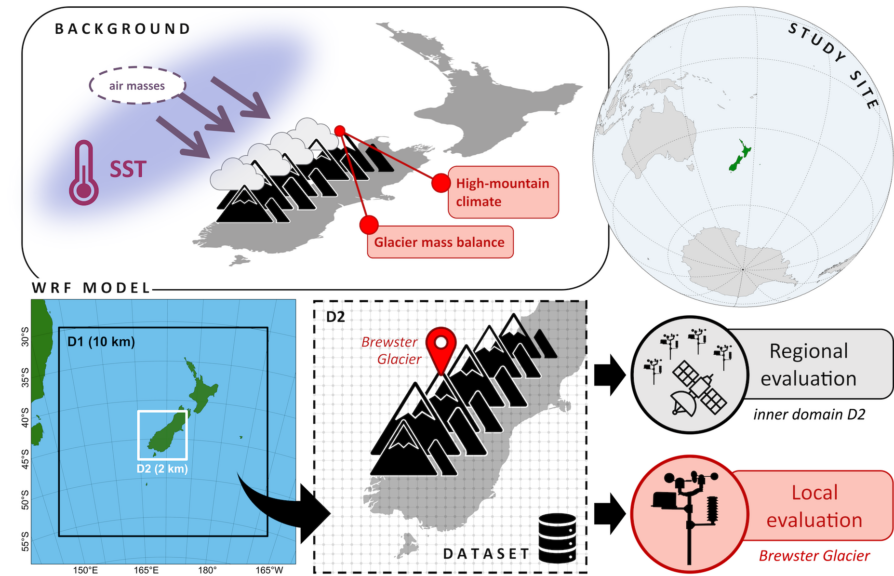
A new, high-resolution atmospheric dataset for southern New Zealand, 2005–2020

The regional climate of New Zealand’s South Island is shaped by the interaction of the Southern Hemisphere westerlies with the complex orography of the Southern Alps. Due to its isolated geographical setting in the south-west Pacific, the influence of the surrounding oceans on the atmospheric circulation is strong. Therefore, variations in sea surface temperature (SST) impact various spatial and temporal scales and are statistically detectable down to temperature anomalies and glacier mass changes in the high mountains of the Southern Alps. To enable future studies on the processes that govern the link between large-scale SST and local-scale high-mountain climate, we utilized dynamical downscaling with the Weather Research and Forecasting (WRF) model to produce a regional atmospheric modelling dataset for the South Island of New Zealand over a 16-year period between 2005 and 2020. The 2 km horizontal resolution ensures realistic representation of high-mountain topography and glaciers, as well as explicit simulation of convection. The dataset is extensively evaluated against observations, including weather station and satellite data, on both regional (in the inner domain) and local (on Brewster Glacier in the Southern Alps) scales. Variability in both atmospheric water content and near-surface meteorological conditions is well captured, with minor seasonal and spatial biases. The local high-mountain climate at Brewster Glacier, where land use and topographic model settings have been optimized, yields remarkable accuracy on both monthly and daily time scales. The data provide a valuable resource to researchers from various disciplines studying the local and regional impacts of climate variability on society, economies and ecosystems in New Zealand. The model output from the highest resolution model domain is available for download in daily temporal resolution from a public repository at the German Climate Computation Center (DKRZ) in Hamburg, Germany (Kropač et al., 2023; 16-year WRF simulation for the Southern Alps of New Zealand, World Data Center for Climate (WDCC) at DKRZ [data set], https://doi.org/10.26050/WDCC/NZ-PROXY_16yrWRF).

https://rmets.onlinelibrary.wiley.com/doi/10.1002/gdj3.263

Publications

Out-of-the-box calving-front detection method using deep learning

Glaciers across the globe react to the changing climate. Monitoring the transformation of glaciers is essential for projecting their contribution to global mean sea level rise. The delineation of glacier-calving fronts is an important part of the satellite-based monitoring process. This work presents a calving-front extraction method based on the deep learning framework nnU-Net, which stands for no new U-Net. The framework automates the training of a popular neural network, called U-Net, designed for segmentation tasks. Our presented method marks the calving front in synthetic aperture radar (SAR) images of glaciers. The images are taken by six different sensor systems. A benchmark dataset for calving-front extraction is used for training and evaluation. The dataset contains two labels for each image. One label denotes a classic image segmentation into different zones (glacier, ocean, rock, and no information available). The other label marks the edge between the glacier and the ocean, i.e., the calving front. In this work, the nnU-Net is modified to predict both labels simultaneously. In the field of machine learning, the prediction of multiple labels is referred to as multi-task learning (MTL). The resulting predictions of both labels benefit from simultaneous optimization. For further testing of the capabilities of MTL, two different network architectures are compared, and an additional task, the segmentation of the glacier outline, is added to the training. In the end, we show that fusing the label of the calving front and the zone label is the most efficient way to optimize both tasks with no significant accuracy reduction compared to the MTL neural-network architectures. The automatic detection of the calving front with an nnU-Net trained on fused labels improves from the baseline mean distance error (MDE) of 753±76 to 541±84 m. The scripts for our experiments are published on GitHub (https://github.com/ho11laqe/nnUNet_calvingfront_detection, last access: 20 November 2023). An easy-access version is published on Hugging Face (https://huggingface.co/spaces/ho11laqe/nnUNet_calvingfront_detection, last access: 20 November 2023).

https://tc.copernicus.org/articles/17/4957/2023/